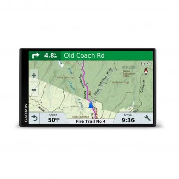

Garmin Zumo XT2 Motorbike GPS
 or 4 payments of $224.75 with Wizit learn more
FREE SHIPPING – Pl allow 2-4 days for processing & dispatch
Garmin Zumo XT2 Motorcycle GPS
- The bright 6″ display is glove-friendly and packed with features to help you find the perfect motorcycle route.
- The bright 6″ display is easy to read, no matter the weather or light conditions.
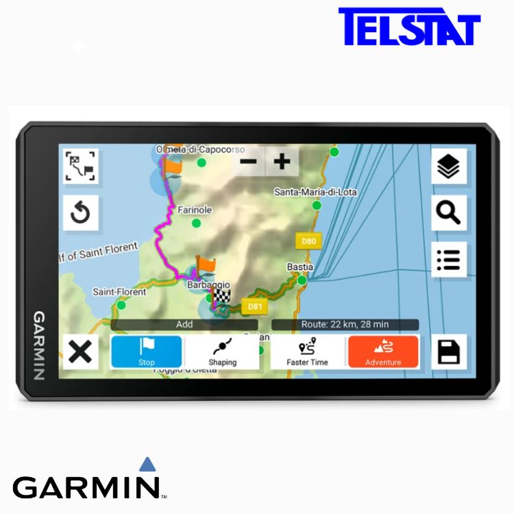
- Create custom routes with the visual route planner.
- Find the twists and turns with the Garmin Adventurous Routing™ setting.
- See popular moto paths to discover new places to ride.
- Start a group ride to see positions of other riders on the display1.
- Switch from street maps to topographic maps to satellite imagery with just a tap.
ULTRABRIGHT DISPLAY
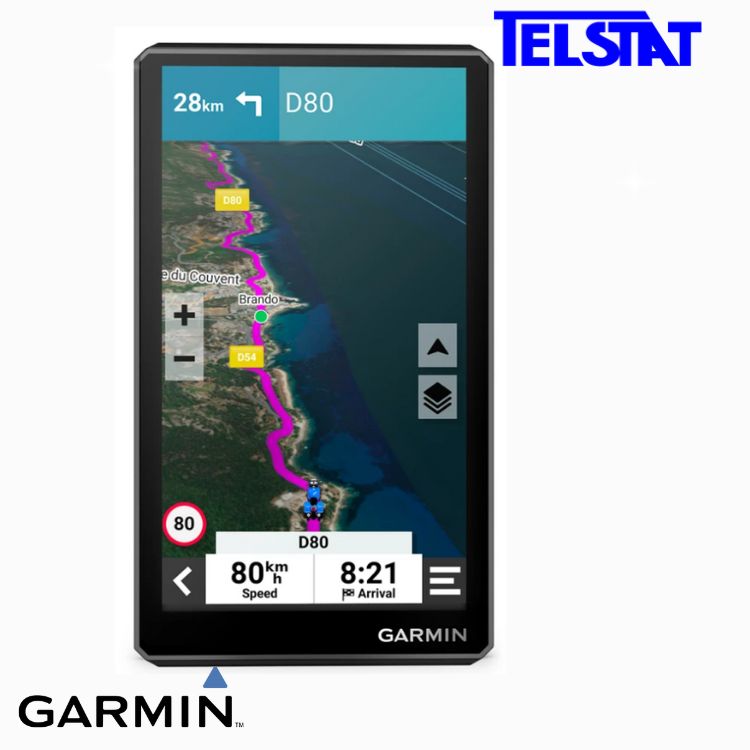
The 6″ display is 15% larger than previous models and features an even brighter HD resolution in landscape or portrait mode.
DESIGNED TO ENDURE
Rain? Vibration? Dust? Doesn’t matter. This device is built to withstand all kinds of weather (IPX7) and rough terrain.
VISUAL ROUTE PLANNER
Plan a custom route on the device, or use the app with a compatible smartphone.
Group Tracking
Use the Tread® app on your smartphone and/or zūmo XT2 device to track friends with the Group Ride Mobile feature1. Or, use the Group Ride Tracker accessory2 (sold separately) for tracking other -equipped riders with no cellular coverage needed.
SIMPLE MAP SWITCHING
Quickly toggle between on-road maps, topographic maps and BirdsEye Direct satellite imagery, so you can always have the perfect map for your ride.
BIRDSEYE DIRECT SATELLITE IMAGERY
Use satellite imagery from around the world to help you navigate. Download the maps directly to your device via Wi-Fi® technology3. No annual subscription required.
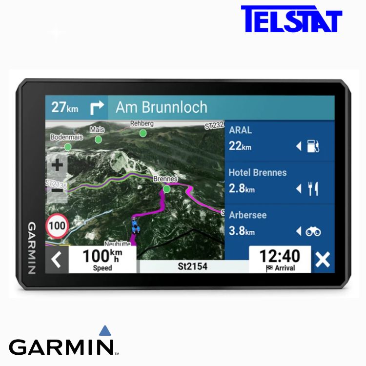
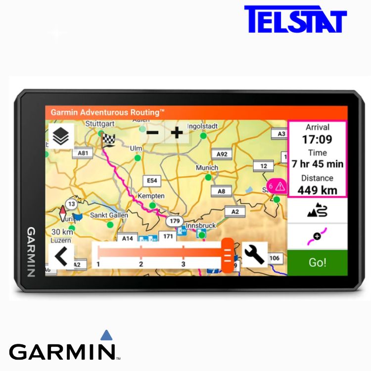
GARMIN ADVENTUROUS ROUTING
Straight roads are boring. Find the most thrilling routes with hills, curves and sights, and choose from 4 levels of difficulty.
GREAT RIDES
Find new routes on the Tread smartphone app. Bookmark them to automatically sync to your , and add difficulty ratings and upload photos to share with other riders.
POPULAR PATHS
See popular moto paths ridden by other riders to find new and exciting routes to explore.
RIDE SUMMARIES
Use the Tread® app to review your ride details, including speed, acceleration, decelerations, elevation and more.
TRACK RECORDER
Record your ride data such speed, distance, acceleration and more and share the details with friends on Tread® app.
SHARE YOUR FAVOURITE ROUTES
Easily send GPX files from your phone or third-party sources to your sat nav. Share GPX files with fellow riders by using the Tread® app.
Manage Your Data
Easily manage tracks and routes across your sat nav and compatible smartphone by using the Tread® app.
TRENDY PLACES FEATURE
Discover the best spots along your route with suggestions for trendy places.
LOCAL SPOTS
Find local places to visit and exciting activities to try near your current location with local spot recommendations.
RIDER ALERTS
Get alerts for hazards along your route, such as upcoming sharp curves, speed changes and more.
MUSIC
Stream music from your smartphone through the sat nav, or play MP3 files stored on the sat nav — all to your connected helmet or headset.
WIRELESS UPDATES
Built-in Wi-Fi3 connectivity makes it easy to keep your maps and software up to date without using a computer. On-screen cues show when new updates are available.
EXTENSIVE MAP COVERAGE
Preloaded topographic maps with 3D terrain and street maps for Europe and Middle East. Africa including Tracks4Africa, North and South America, Australia and New Zealand maps are available as free downloads via garmin.com/express.
LIVE TRAFFIC AND WEATHER
Access real-time traffic and weather, share routes with other riders, and get phone notifications via the Tread® app4.
INCIDENT NOTIFICATIONS
If an incident occurs, a text message with location information is automatically sent to your predetermined contact4.
BLUETOOTH® CONNECTIVITY
Hear turn-by-turn directions or hands-free calling from your compatible smartphone through a connected helmet or headset.
INREACH® COMPATIBILITY
Pair with a compatible inReach satellite communicator5 for two-way messaging, location sharing and, in case of emergencies, SOS capabilities.
CONTROL YOUR ACCESSORIES
Pair the motorcycle sat nav with the compatible Garmin PowerSwitch™ digital switch box (sold separately) to enable on-screen control of your motorcycle’s 12-volt electronics.
Get more from your device with the Tread® app.Learn more
Communicate globally with inReach® satellite technology5.
Specifications:
- Dimension – 15.6 x 8.9 x 2.5 cm (6.15” W x 3.5” H x 1” D)
- Weight – 340g
- Waterproof – IPX7
- Display Type – Multi-touch, glass, high brightness HD colour TFT with white backlight
- Display Size – 13.3 x 7.5 cm (5.3”W x 3.6”H); 15.3 cm diag (6”)
- Display Resolution – 1280 x 720 pixels
- Dual-Orientation Display
- Handlebar mount (up to 1″)
- Drop rating – MIL-STD-810
- Battery type – Rechargeable lithium-ion
- Battery life – Up to 6 hours (up to 3.5 hours at 100% backlight)
In the Box:
- zūmo® XT2
- Motorcycle mount and hardware
- Motorcycle power cable
- USB cable
- Documentation